billsportsmaps.com

July 19, 2026

Nico Williams, the man who made the sublime assist for the goal which won the 2026 WC for Spain?

Filed under: Spain — admin @ 9:05 pm

Nico Williams, the man who made that sublime assist, for the goal, which won the 2026 WC for Spain?

Well…Nico, and his brother Inaki, are both the sons of Ghanaian immigrants. Ghanaian immigrants who had to cross the N African desert barefoot, into Spain, via the Spanish N African enclave of Melilla, to illegally emigrate.

Their parents were subsequently arrested, and were set to be extradited back to Africa. If not for an immigration lawyer (whose name they never got), who was able to secure the Ghanaian couple a safe haven.

{See: My parents crossed the desert barefoot to get to Spain, (by Sid Lowe at guardian.com/football).}

So the Williams family got to live in Spain, a nation which is basically 97.5-percent Caucasian.

Talk about karma, in this WC, which was overshadowed by a man who currently resides in the White House.

A man whose primary political platform which got himself into the White House in the first place was, to, you know, get rid of all the immigrants, Chapter 14 or otherwise, whom were supposedly ruining this country (unless they are [or were] white, like Donald Trump’s Nazi dad was). {See: ‘Donald Trump and the Ku Klux Klan: A History‘ (by Evan Osnos at the New Yorker, 2016).} :l

And, of course, the right-wing media will try their hardest to bury this story.

-Bill Turianski; twitter.com/billsportsmaps.


July 3, 2026

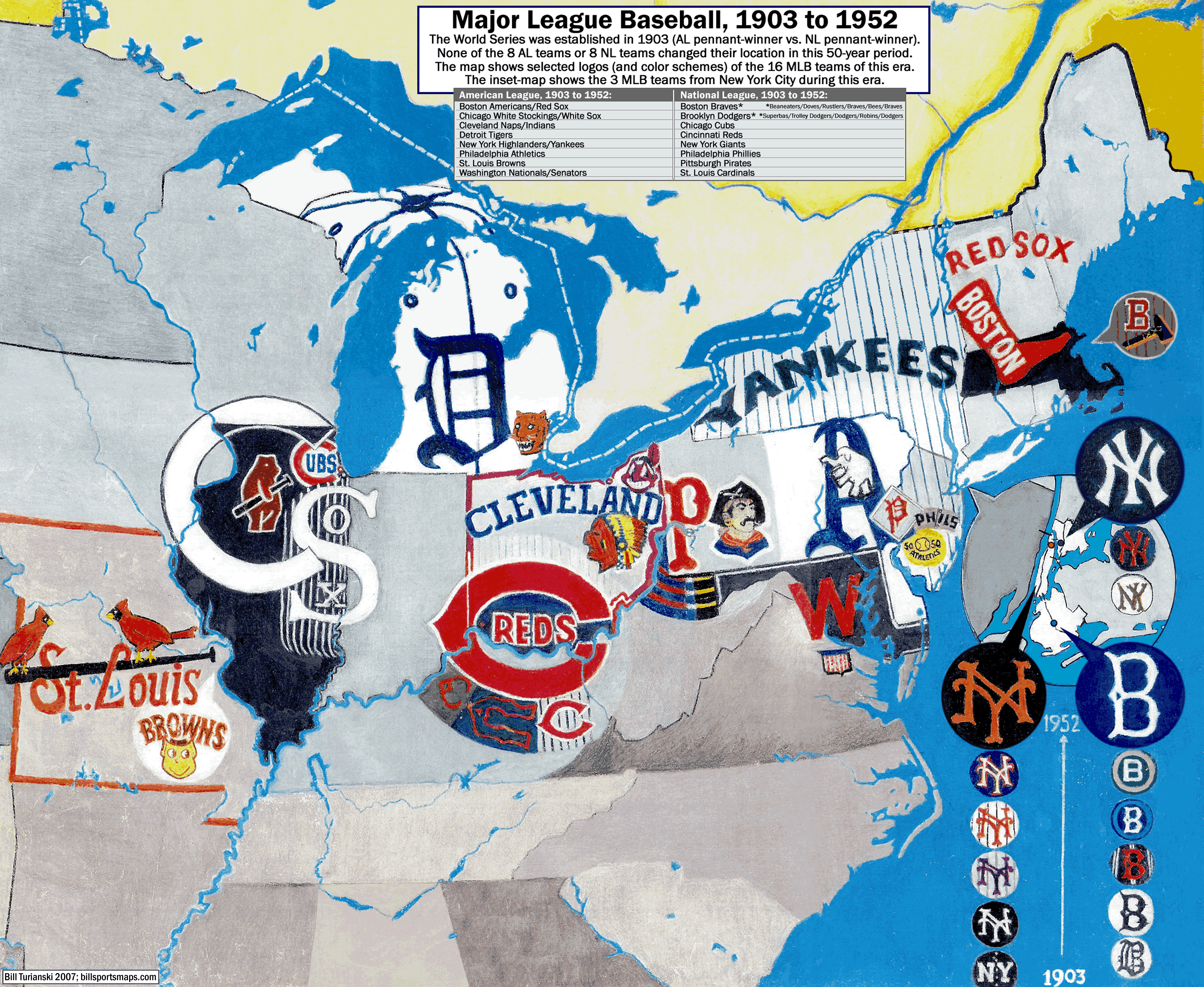
Major League Baseball, 1903 to 1952 [Hand-drawn map].

Filed under: Baseball,Hand Drawn Maps,Retro maps — admin @ 11:20 pm

mlb_hand-drawn-map_16-mlb-teams_logos-circa-1903-1952_billsportsmaps_enlarged_post_c_.gif
Major League Baseball, 1903 to 1952 [Hand-drawn map]


By Bill Turianski on 3 July 2026; twitter.com/billsportsmaps.

Note: this is a re-post from 3 years ago, and also from 19 years ago, because i am old and lazy now. Happy extended 4th of July to everyone :|

    Major League Baseball, 1903 to 1952 [Hand-drawn map]

Between 1903 and 1952, there was no franchise movement among the 8 National League and 8 American League baseball clubs. This map shows all the 16 MLB clubs from that 50-year time period, with selected emblems, cap crests, and uniform details.

Included on the map is an inset map of the Greater New York City area, which, from 1903 to 1957, boasted 3 Major League ball clubs. Their locations back then are shown: Yankee Stadium (1923) in The Bronx (New York Yankees), the Polo Grounds in Manhattan (New York Giants), and Ebbets Field in Brooklyn (Brooklyn Dodgers).

The evolution of these three NYC ball clubs’ crests, and the evolution of their colors, is also shown, within, and also right below, the inset-map.

PS, the New York Yankees are to this day, of course, still in The Bronx. But in 1958, the Brooklyn Dodgers and the New York Giants both forsook their faithful fans in New York – and bolted to California. For municipal hand-outs, including bags of money, and free and spuriously-acquired prime real estate {see: Battle of Chavez Ravine; see: The Dark Heart of Dodger Stadium: The History of Chavez Ravine}.

So in that respect – namely, pro sports teams which are part of a closed-shop-cartel [MLB], yet which still demand public-funding or they will shove off to some-other-town that’s willing to throw cash at them – well, the LA dodgers and the SF giants were way ahead of their time. In a bad way.

This map would not have been possible without the incredible book “Baseball Uniforms of the 20th Century” {at Amazon, here}. That book was researched, written, and illustrated by Marc Okkonen. His artwork for this book can now be found as the main uniform database (from 1900 to 1994) for the Baseball Hall of Fame site “Dressed to the Nines – A History of the Baseball Uniform”…{exhibits.baseballhalloffame.org/dressed_to_the_nines/database}

I made this map in early 1993, after my two brothers had given me, for Christmas, the now-out-of-print “Baseball Uniforms of the 20th Century”.

To draw the map, I used Caran d’Ache watercolor pencils and graphite pencil, on Bienfang semi-transparent paper. In 2023, I added the banner at the top of the map. The initial map probably took me about 90 hours or so to draw.
___


Powered by WordPress